


May 3, 2021–8:50 a.m.
NATIONAL WEATHER SERVICE
 There is a transition to a more active pattern, several disturbances/frontal systems will increase the chances for strong to severe storms across the area both today (Monday) and again Tuesday/Tuesday night. Below are our current thoughts on the particular main hazards and timing.
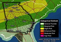
Today: The first disturbance will allow for scattered strong to isolated severe storms. Some may organize into more of a line in north GA by early afternoon that could push farther south into central GA by late afternoon/evening. A Slight Risk is in effect for the central majority of the area, and a Marginal Risk is in effect across the far north and far south.
Primary Hazards
- Damaging Wind Gusts >60 mph
- Large hail
- Locally Heavy Rainfall and Frequent Lightning
- Brief tornado cannot be ruled out
Tuesday/Tuesday Night: The second disturbance and frontal system will bring another round of strong to severe storms. The greatest chance will be in the afternoon/overnight period. An Enhanced Risk is in effect for some western portions of the area, while a Slight Risk has expanded across the NW majority of the area. A Marginal Risk is in effect across other portions of central GA.
Primary Hazards
- Damaging Wind Gusts >60 mph
- Isolated Tornadoes
- Locally Heavy Rainfall and Frequent Lightning