Tuesday, January 16, 2024–10:39 a.m.
-Staff reports-

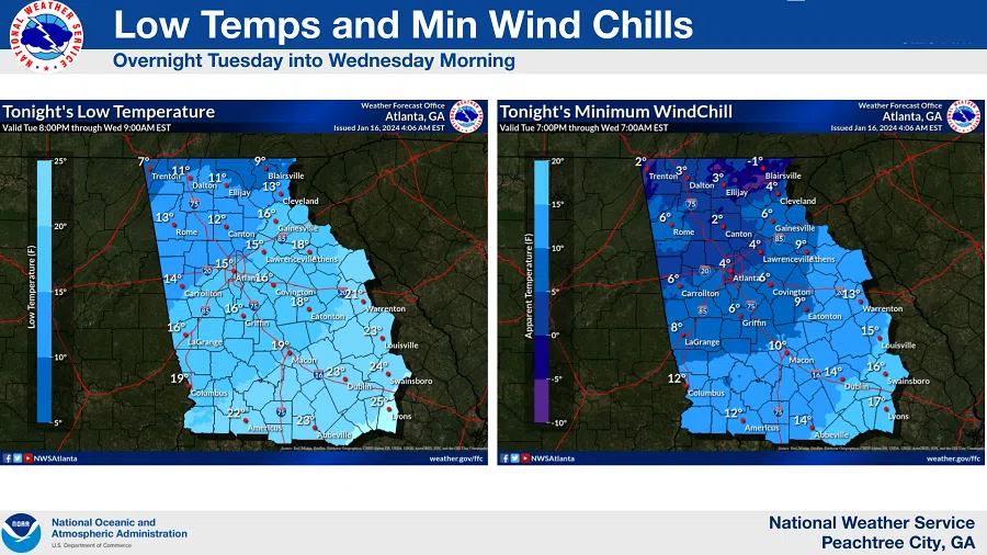
A Wind Chill Advisory will go into effect at 5 PM Tuesday through 10 AM Wednesday for dangerous wind chills across north Georgia and portions of central Georgia.
Areas of standing water from recent rainfall may begin to freeze over as temperatures remain below 32 degrees and high winds move in from the northwest.
Areas of patchy ice may develop on untreated roadways or elevated surfaces such as bridges and overpasses.
The dangerous cold could lead to frostbite or hypothermia.
Appropriate precautions should be taken to protect yourself and vulnerable populations.
According to Floyd County Emergency Management:
The area experienced mainly rain events Monday night into Tuesday morning with temperatures remaining above freezing until 5 AM. Ground temps also remained above freezing which lessened the impact of slippery road conditions this morning.
However, our temperatures will remain below freezing with arctic wind chills extending well into the evening hours on Tuesday, producing single-digit temperatures.
Any water remaining on the roadways will refreeze causing some dangerous black ice road conditions for commuters today and tomorrow morning, so use extreme caution when driving on Tuesday and Wednesday.
Floyd County EMA will continue to monitor weather and road conditions for the next few days and begin preparations for Friday through Sunday’s extreme cold weather predictions for our area.
Don’t forget about pets and other outside animals during these next few days of cold weather.